Phase 1 Route and Design
Phase 1 of the Clintonville Neighborhood Greenways has been funded! We are in the process of working on a detailed route and design with the City of Columbus.
This is a working document outlining our recommendations for Phase 1 of the Clintonville Neighborhood Greenways. It’s intended to be a starting point for the detailed designs that will be developed by the City of Columbus.
Strategy
Our strategy for building the Neighborhood Greenways is to start with the minimal infrastructure that achieves our design goals (known in the tech world as a “minimal viable product”). We will then monitor the success of the Neighborhood Greenways and evolve and improve the design as needed.
In our case, the minimal viable product is a network of neighborhood roads that feel safe for all ages and abilities. This boils down to the following:
- Traffic speed under 25mph
- Traffic volume less than 1000 cars/day
- People feel relaxed and safe biking and walking
All these metrics can be measured, recorded, and tracked over time. If we meet our goals, no additional treatments are needed. If we don’t meet our goals then additional treatments can be considered.
General Design Guidelines
Neighborhood greenways consist of the following elements:
- A distinctive look so that all road users are aware of the neighborhood greenway. People driving are alerted that the street is prioritized for biking and walking.
- Treatments to reduce vehicle speed and volume as needed. The goal is to keep speed under 25mph and ADT under 1000 cars per day.
- Improved treatments at busy intersections to help people biking and walking cross more easily.
- Free-flow travel for people biking and walking by assigning the right-of-way to the neighborhood greenway at intersections wherever possible.
- Way-finding signs guiding people along the route and letting them know what is nearby, for example parks, schools, and local businesses.
Route and design recommendations
The Phase 1 route was chosen to connect to all parts of Clintonville while remaining easy to implement. Wherever possible, we chose streets that already met our goals for Neighborhood Greenways so that minimal changes will be required.
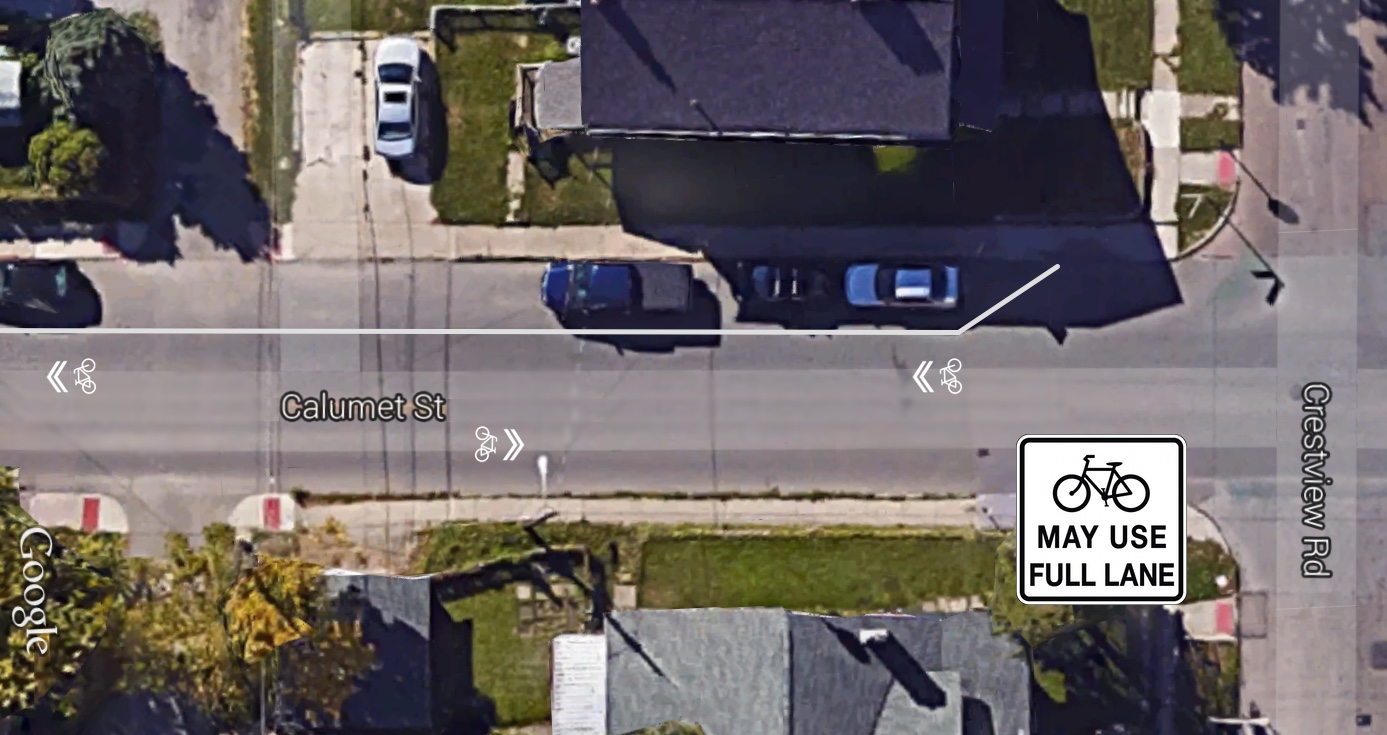
Calumet Street
Calumet Street (‘A’ on map) is the biggest challenge on the Neighborhood Greenways route. Traffic volume is 2200 cars/day - twice what we would like. 85th percentile speed is 33mph in some places - well above our goal of 25mph. Because of the windy nature of the road and higher traffic volumes, unsafe passes are common, making this road unsuitable in it’s current condition for families and other risk-averse people.
Calumet is a neighborhood collector, which means traffic restrictions will be difficult. Because on-street parking is widely used, especially south of Weber, we cannot make room for bike lanes.
Visually narrow road. The wider sections of Calumet lead to faster speeds. One option is to stripe out an 8’ parking lane. Also evaluate for green infrastructure such as curb bump outs in coordination with Columbus Blueprint.
Remove yellow center line. A yellow center line encourages higher speeds and more dangerous passing behavior. Use short sections of yellow center lines only at major intersections (Arcadia, Weber, Broadway) and around blind curves.
Use more frequent sharrows. More frequent sharrows are advised for roads with higher traffic volume and speed. Consider sharrows at 75 to 100 foot intervals.
Add “Bikes may use full lane” signs. These signs are the recommended standard for clarifying that bikes are allowed full use of the road. “Share the road” signs should not be used.
Intersection of Torrence Road and High Street
Traffic at this intersection (‘B’ on map) increased significantly after the new Starbucks opened. Although drivers are fairly cautious and aware of people biking and walking, the large volume of cars can make navigating this intersection tricky.
Add ladder-style crosswalks. More prominent crosswalks will highlight the Neighborhood Greenways crossing, raise awareness of the increased bike and pedestrian traffic, and make people walking and biking feel more comfortable.
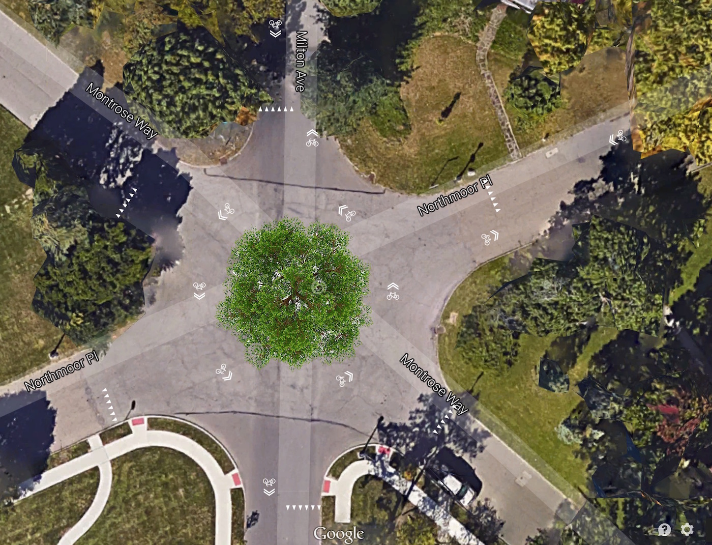
Intersection of Milton, Northmoor, and Montrose Way
This 6-way intersection (‘C’ on map) is large and has numerous conflict points. While traffic volume is generally low, it can still be tricky to navigate with bikes, cars and pedestrians all using the same space.
Add a planted traffic circle. Traffic entering the circle yields to traffic that’s already in the circle.
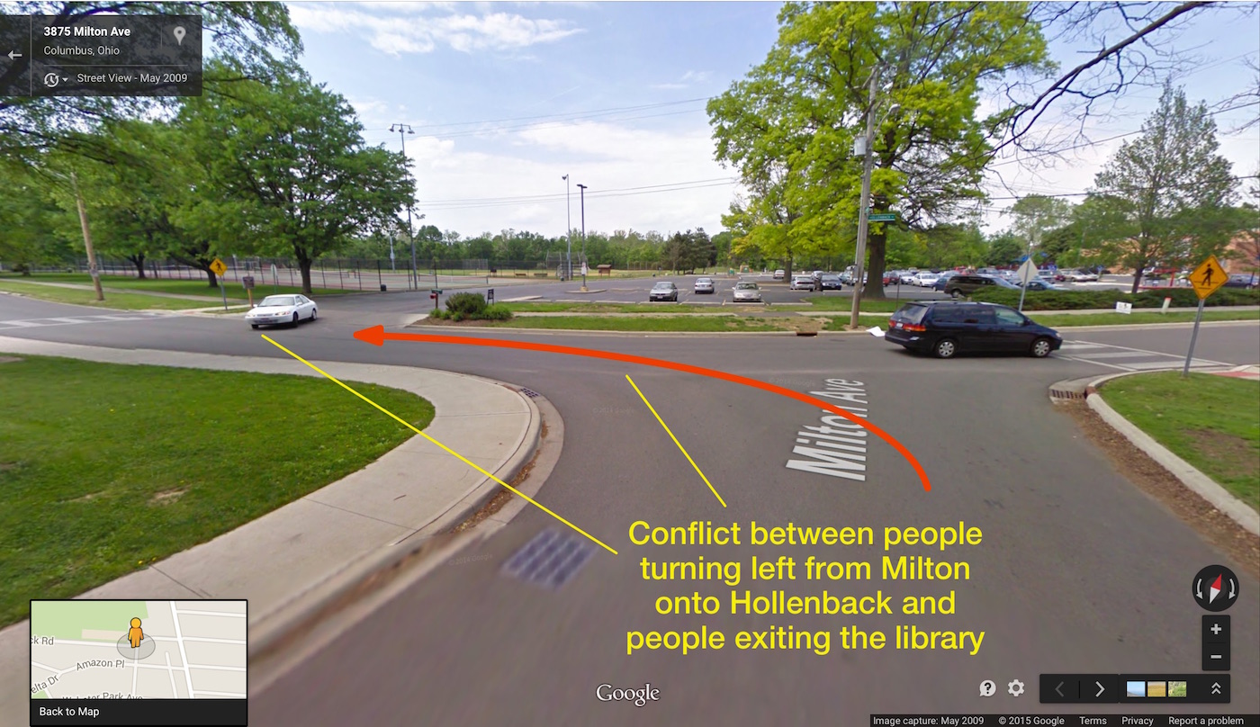
Intersection of Milton and Hollenback
This intersection (‘D’ on map) is difficult to navigate because it’s offset with the exit from the library. Traffic is generally slow and people navigate cautiously. The most common conflict is between people turning left from Milton onto Hollenback and people exiting the library.
Long-term this intersection should be re-aligned with the library exit and converted to a 4-way stop. For Phase 1 consider adding additional sharrows through the turn to highlight the presence of bikes.
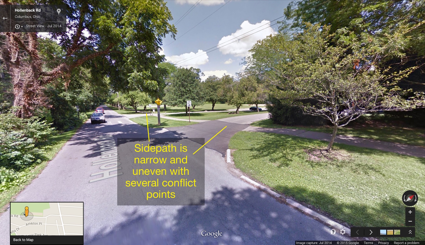
Hollenback
Hollenback (‘E’ on map) is a park road. Traffic volume is sometimes high, especially on evenings with children’s soccer. However speeds are low and people are alert.
There is a side path that parallels Hollenback. This path is narrow and the surface is uneven. There are several conflict points where the path crosses driveways. Getting on and off the path also requires crossing traffic.
While some people may choose to use the side path, the Neighborhood Greenways route should use Hollenback and should be marked with sharrows.
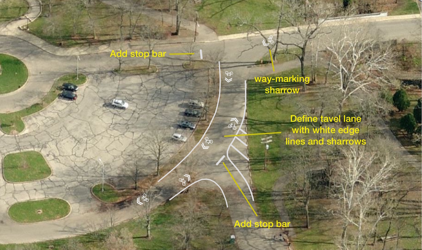
Shelter house parking lot
The route past the shelter house parking lot (‘F’ on map) is confusing. It appears the road goes straight into the parking lot. There are two parking lot exits with stop signs, but because of the curvy nature of the road, it’s not clear who has the right of way.
Use sharrows and a white edge line to define the travel lane. Add stop bars at parking lot exits to clarify right of way.
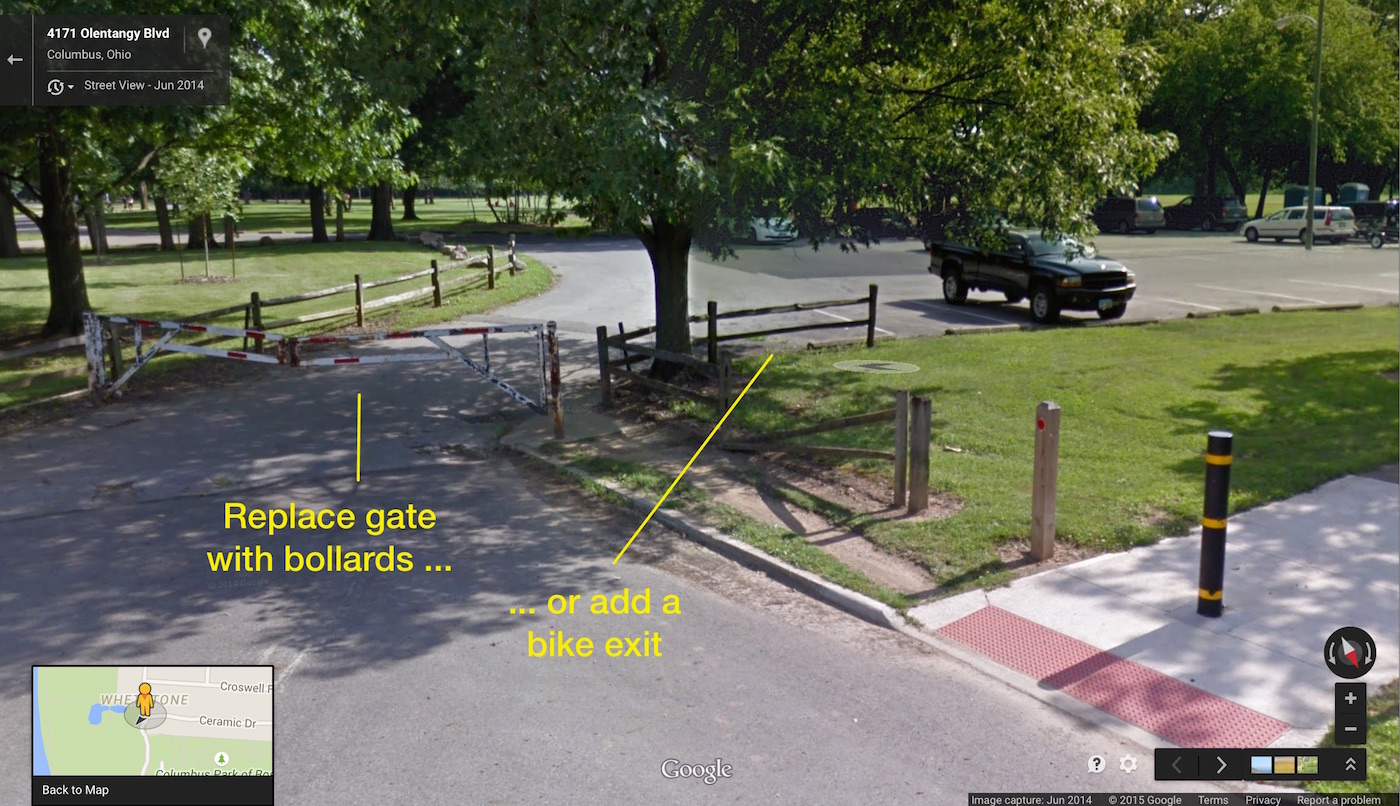
Exit to Olentangy Blvd
Replace gate with bollards, allowing people biking to pass through, or add a new bike exit following the desired direction of travel (‘G’ on map)
Intersection of Olentangy Blvd and Henderson Road
The light cycle at this intersection (‘H’ on map) is very long. This adds significant delay to trips on the Neighborhood Greenways route. It also causes a large number of cars to queue up on Olentangy Blvd during rush hour. Evaluate shortening the light cycle to reduce delay for Neighborhood Greenways traffic.
There is a problem with drivers bullying people on bikes at this intersection. Drivers that want to turn right don’t like waiting behind bikes that are going straight and sometimes honk and yell at them to “get out of the road”. Bikes often go up on the sidewalk ramps to wait which causes problems at they re-integrate into the traffic flow when the light changes.
Evaluate the intersection for bike boxes. Bike boxes would create space for bikes and would clearly communicate that people on bikes should wait in the road and not on the sidewalk ramps.
Add ladder-style crosswalks. More prominent crosswalks will highlight the Neighborhood Greenways crossing, raise awareness of the increased bike and pedestrian traffic, and make people walking and biking feel more comfortable.
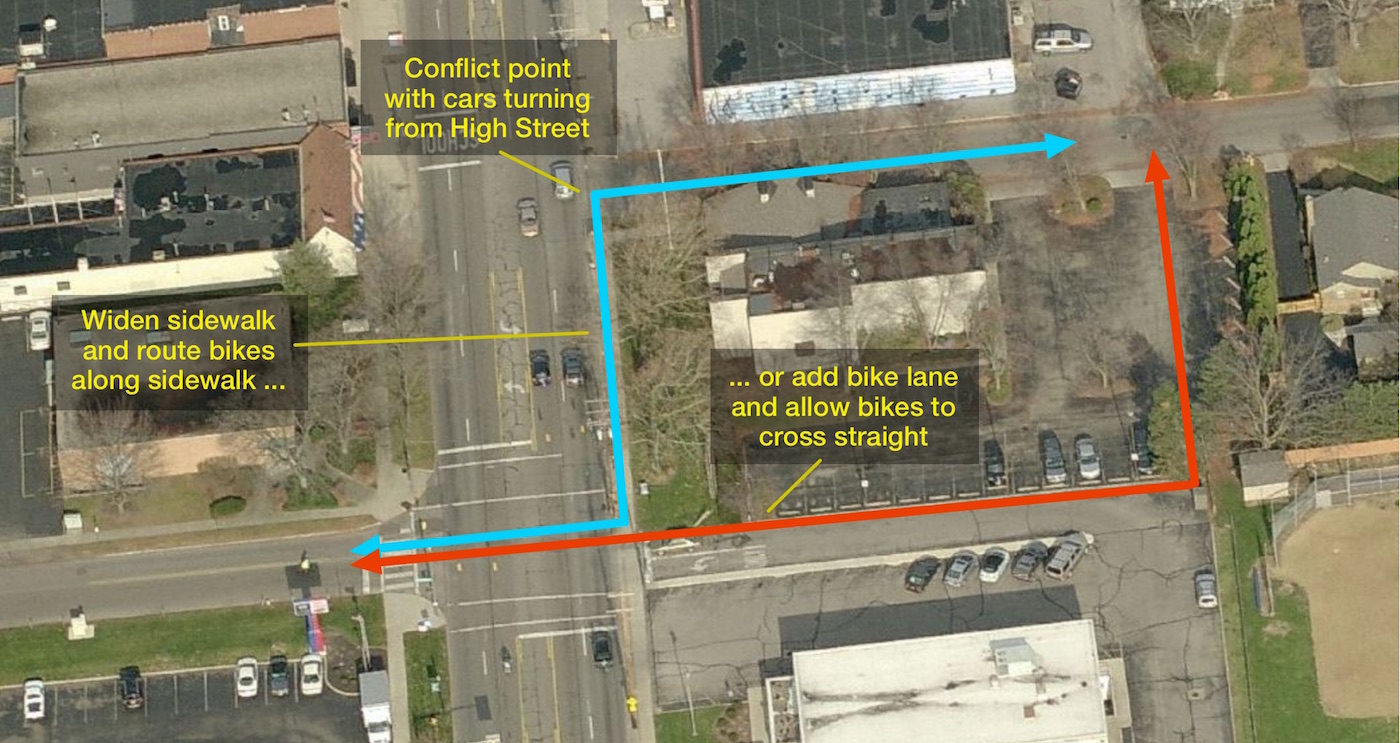
Intersection of Weisheimer Road and High Street
This intersection is offset (‘I’ on map). However, since there is a 4-way traffic signal, it would be possible to re-align the intersection for bikes. This could be done by converting one of the bank exit lanes to a two-way bike lane, or by adding a two-way bike lane to the north of the bank exit. The north-east corner of Weisheimer and High is being redeveloped, so this is a perfect opportunity to start the discussion.
A second option would be to improve the sidewalk on the east side of High Street and route bikes along the sidewalk in front of the business. This creates a conflict point with cars turning from High Street onto E. Weisheimer Road. The conflict could be eliminated with a choker entrance preventing turns onto E. Weisheimer Rd.
In either case add ladder-style crosswalks. More prominent crosswalks will highlight the Neighborhood Greenway crossing and make people walking and biking feel more comfortable.
Road markings and street signs
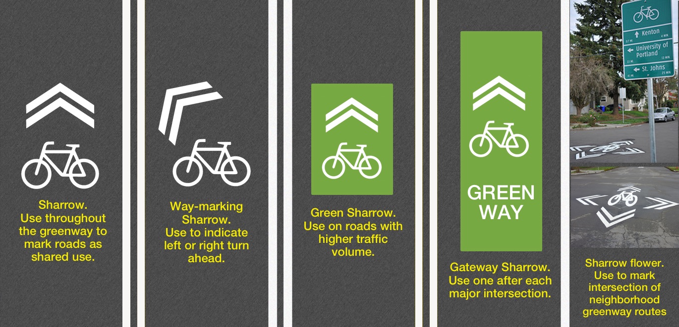
Road markings
- Sharrow - use throughout the greenway to mark roads as shared use.
- Way-marking sharrow - use to indicate left or right turn ahead.
- Green sharrow - use on roads with higher volume to emphasize shared use lanes.
- Gateway sharrow - use one gateway sharrow after each major intersection to alert road users to the presence of the Neighborhood Greenways.
- Sharrow flower - use to mark intersections of Neighborhood Greenways routes to alert people that they have a choice to make.
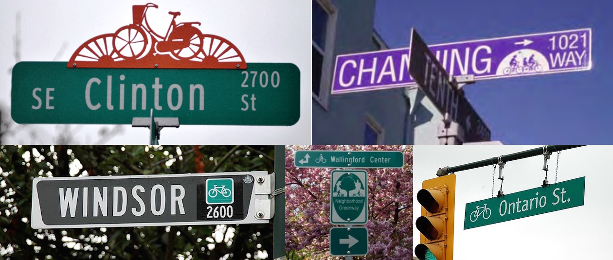
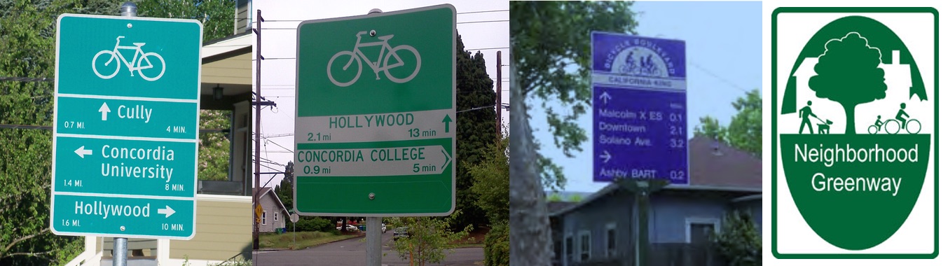
Street signs and way-finding signs
Branded street signs and way-finding signs add awareness of the Neighborhood Greenways route. Examples of neighborhood greenway street signs.
Examples of neighborhood greenway way-finding.
Traffic volume targets
Based on guidance from engineers in Portland, we feel that targeting traffic volumes of under 1000 cars/day is essential to making a neighborhood greenway safe enough for all ages and abilities.
Below are the guidelines that Portland is proposing to become official policy for their neighborhood greenways:
- 1,000 autos per day is the desired maximum.
- 1,500+ autos per day is acceptable, but diversion is considered on a case by case basis and recommended if there is an expectation that other changes, or the greenway’s location, will attract significant traffic to the project street.
- More than 2,000 autos per day necessitates diversion in some form if the neighborhood greenway street is to be a shared space with auto traffic. This is primarily because Portland has a desired maximum speed of 20 mph, and state law permits us to reduce the residential statutory speed of 25 mph by 5 mph on greenway streets, but only if the residential street has less than 2,000 autos per day.
This guidance is based in part on research documented in Low-Stress Bicycling and Network Connectivity (PDF 2.4 MB)
Other cities’ design guidelines
Portland OR and Berkeley CA both have successful neighborhood greenway networks. For reference their neighborhood greenway design guidelines are linked below.
Portland, OR
Fundamentals of Bicycle Boulevard Planning & Design
(PDF 5.2 MB)
Berkeley, CA
Bicycle Boulevard Design Tools and Guidelines
Edit: This post was updated on 9/11/2015 to align with current best practices and feedback from the city.